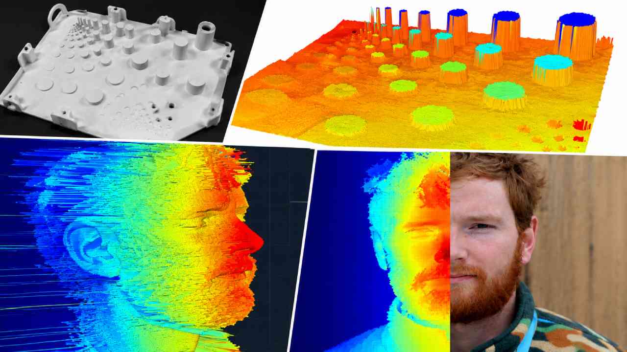
Mayumiotero – LiDAR Imaging is a visual technology that uses laser light to measure distance and capture the shape of physical environments. LiDAR stands for Light Detection and Ranging. Instead of recording a flat scene like a conventional photograph, the system collects spatial measurements. It sends laser pulses toward surrounding surfaces and detects the returning light. Then, the system calculates distance from the travel time of those pulses. This process can happen rapidly across many points. As a result, LiDAR can create detailed information about buildings, roads, trees, vehicles, and terrain. The technology has become useful across mapping, robotics, construction, research, and other fields. Moreover, LiDAR adds something important to digital visualization: depth. A camera can capture how an object looks. LiDAR, however, can help determine where surfaces exist in three-dimensional space. That difference makes the technology valuable when accurate spatial information matters.
Read Also: Google Launches Motion Assist to Ease Travel Sickness on Android
Laser Pulses Provide the Foundation for LiDAR Measurements
The basic idea behind LiDAR Imaging is surprisingly straightforward. A LiDAR sensor emits a pulse of laser light toward an object. The light reaches the surface and part of it returns to the sensor. Next, the system measures how long that round trip takes. Since the speed of light is known, the device can calculate distance from the timing information. However, a real LiDAR system does not depend on a single measurement. It repeats the process across many directions and points. Therefore, the sensor gradually builds a detailed representation of its surroundings. The exact performance varies between systems. Range, scanning method, laser wavelength, sensor design, and environmental conditions can all affect the results. Nevertheless, the underlying principle remains similar. Light travels outward, reflects from a surface, and returns with useful distance information. This simple cycle forms the basis of sophisticated three-dimensional mapping.
Point Clouds Build a Digital Picture of the Physical World
One of the most important outputs of LiDAR Imaging is a point cloud. A point cloud contains large numbers of spatial points. Each point represents a measured location in three-dimensional space. When these measurements appear together, they begin to reveal the shape of the environment. For example, points collected around a building can outline its walls, roof, windows, and surrounding structures. Similarly, measurements across a landscape can represent terrain, vegetation, and other surface features. However, raw point clouds are only the beginning. Software can process the data to classify surfaces or create more usable visual models. In some workflows, LiDAR data can also be combined with camera imagery. This adds visual information such as color and texture. Consequently, the final representation can become easier for people to interpret. The transformation from individual laser measurements into a recognizable 3D scene is one of LiDAR’s most fascinating capabilities.
LiDAR and Cameras See the Environment Differently
Cameras and LiDAR Imaging can both collect information about the same environment, yet they do so differently. A camera is excellent at capturing color, texture, patterns, and fine visual details. This makes cameras useful for identifying signs, markings, faces, and many other visual features. LiDAR focuses more directly on geometry and distance. Therefore, it can provide spatial measurements that complement camera images. Consider a vehicle traveling along a road. A camera may capture a cyclist, road markings, traffic lights, and surrounding buildings. Meanwhile, LiDAR can describe the spatial position and shape of nearby surfaces. Neither technology needs to replace the other. Instead, combining different sensors can provide richer information. Radar may also join such systems when its characteristics are useful. This approach is commonly called sensor fusion. In practice, each technology contributes different strengths to environmental perception.
3D Mapping Is One of LiDAR’s Most Important Applications
Mapping is a major application for LiDAR Imaging. Sensors can be mounted on aircraft, drones, vehicles, or ground-based equipment. As the platform moves, LiDAR collects distance measurements across the surrounding environment. These measurements can then support three-dimensional maps and terrain models. For example, surveyors can use LiDAR data when studying land surfaces. Engineers can also use 3D scans when documenting infrastructure or planning projects. In addition, airborne LiDAR can help researchers examine landscapes across relatively large areas. The ability to collect spatial measurements efficiently makes the technology useful when manual measurement would be slow or difficult. However, LiDAR data still requires careful processing and interpretation. Accurate positioning, calibration, and suitable workflows remain important. Therefore, the sensor should not be viewed as an automatic solution to every mapping challenge. Its value comes from combining good measurements with appropriate analysis.
Robots Can Use LiDAR to Understand Their Surroundings
Robotics provides another important use case for LiDAR Imaging. A mobile robot needs information about nearby walls, furniture, people, obstacles, and open spaces. LiDAR can provide useful distance measurements for that purpose. As the robot moves, it can repeatedly scan its environment and update its understanding of nearby geometry. Furthermore, LiDAR data can contribute to mapping and localization systems. A robot may compare new measurements with an existing map to estimate its position. Alternatively, it can help build a map while navigating an unfamiliar environment. This concept is closely connected with SLAM, or Simultaneous Localization and Mapping. Still, LiDAR alone does not give a robot human-like understanding. Software must interpret the sensor data and combine it with other information. Cameras, wheel sensors, inertial sensors, and additional technologies may also contribute. Together, these systems help machines move through physical spaces more effectively.
LiDAR Can Support Archaeology and Environmental Research
The potential of LiDAR Imaging extends beyond vehicles and robots. Researchers can use airborne scanning to examine landscapes from above. This can be especially useful when studying terrain across forests or other complex environments. Laser measurements may include returns from vegetation as well as the ground below. With suitable processing, researchers can analyze terrain models that reveal surface features more clearly. Archaeologists have used this capability to investigate landscapes and identify structures that deserve closer study. Meanwhile, environmental researchers can use LiDAR-derived information to examine forests, topography, and changes in physical landscapes. However, LiDAR does not magically see through every object. Dense vegetation, sensor configuration, flight conditions, and data processing can influence what researchers can recover. Therefore, careful interpretation remains essential. Even with those limitations, the ability to capture detailed elevation and structural information has made LiDAR a powerful research tool.
Read Also: Procedural Typography Transforms Modern Digital Letter Design
Smaller Sensors Bring Depth Sensing to Consumer Devices
Not every LiDAR Imaging system is a large rotating scanner mounted on a vehicle. Advances in sensing technology have enabled smaller depth-sensing systems for compact devices. Depending on the product, these sensors can support room measurement, augmented reality, object placement, and 3D scanning applications. This development brings spatial sensing closer to everyday users. For example, a device can gather depth information about a room and use it to improve the placement of virtual objects. Developers can also combine depth data with cameras to build richer spatial experiences. Nevertheless, capabilities vary greatly between consumer sensors and professional surveying systems. A compact depth sensor should not automatically be treated as a replacement for specialized equipment. Range, precision, resolution, and operating conditions can differ substantially. Even so, miniaturization demonstrates how technologies once associated with specialized mapping can gradually become part of mainstream digital experiences.
Weather and Surface Conditions Can Affect LiDAR Performance
Although LiDAR Imaging is powerful, it also has limitations. Laser light must travel through the environment before returning to the sensor. Therefore, atmospheric conditions can affect measurements. Rain, fog, snow, dust, or airborne particles may interfere with laser returns in certain situations. Surface properties can matter as well. Different materials reflect light differently, which may influence how effectively a sensor detects them. Range is another consideration because every LiDAR system has practical operating limits. Moreover, sunlight and other environmental factors may affect certain sensor designs. Engineers address these challenges through hardware improvements, filtering, calibration, and sensor fusion. Consequently, LiDAR is often combined with cameras, radar, or other sensors when reliability is especially important. Understanding these limitations provides a more realistic view of the technology. LiDAR is not perfect vision. Rather, it is a specialized measurement system with strengths and constraints.
LiDAR Imaging Helps Connect Physical and Digital Spaces
The broader importance of LiDAR Imaging comes from its ability to translate physical geometry into digital information. A building can become a point cloud. A road can become a measurable 3D environment. Meanwhile, a room can become spatial data for an augmented reality application. This connection is increasingly relevant as digital systems interact more closely with physical spaces. Digital twins, robotics, immersive visualization, surveying, and spatial computing all depend on reliable information about the real world. LiDAR can provide part of that foundation. However, the future of spatial technology will probably involve several complementary sensors rather than one universal solution. Cameras provide rich visual detail. Radar offers different sensing characteristics. LiDAR contributes precise spatial measurements in many applications. When these technologies work together, machines can build richer representations of their surroundings. That is why LiDAR remains an important part of modern visual and spatial technology.