Mayumiotero – Geographic Information has become one of the most valuable digital assets in today’s connected world. Every location, road, building, forest, and coastline can now be transformed into meaningful spatial data through Geographic Information System (GIS) technology. As a result, governments, researchers, and businesses rely on accurate geographic insights to improve planning and decision-making. Moreover, advances in cloud computing, satellite imagery, and artificial intelligence have accelerated the evolution of GIS beyond traditional mapping. Instead of displaying simple maps, modern GIS reveals patterns, predicts future scenarios, and uncovers relationships that might otherwise remain hidden. Consequently, Geographic Information continues to reshape industries worldwide while helping organizations make smarter, faster, and more reliable decisions.
Read Also: Why OpenAI May Offer a Stake to the US Government and What It Could Mean for AI
The Evolution of Geographic Information in the Digital Era
For decades, maps served primarily as navigation tools. However, Geographic Information has evolved into an intelligent digital resource that combines location data with valuable descriptive information. Today, GIS platforms collect data from satellites, drones, GPS devices, sensors, and mobile applications. These technologies continuously update spatial databases with remarkable precision. Furthermore, cloud-based infrastructure allows users to access geographic information from virtually anywhere. This evolution has significantly improved collaboration between organizations operating across different regions. Therefore, Geographic Information is no longer limited to cartographers or geographers. Instead, professionals in healthcare, logistics, finance, agriculture, and disaster management increasingly depend on spatial intelligence to solve complex challenges more efficiently.
How Geographic Information System Processes Spatial Data
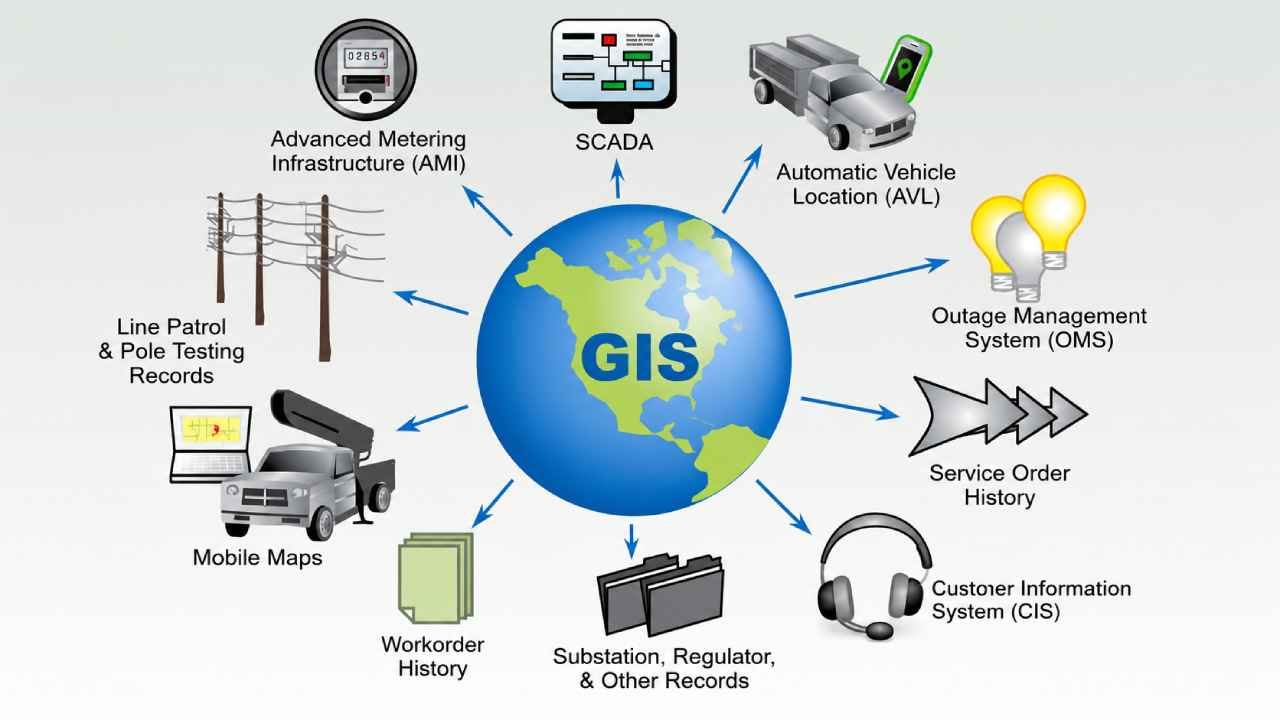
A Geographic Information System operates by organizing multiple layers of spatial information into one integrated platform. Each layer represents specific elements such as roads, rivers, buildings, vegetation, transportation routes, or population density. Subsequently, the software analyzes relationships among these layers to generate meaningful insights. Analysts can compare environmental changes, monitor urban growth, or identify high-risk locations with impressive accuracy. In addition, GIS software automatically updates visualizations when new information becomes available. Because of this capability, organizations can respond quickly to changing conditions while reducing uncertainty. Ultimately, Geographic Information transforms raw geographic coordinates into practical knowledge that supports evidence-based decisions.
Geographic Information Improves Urban Planning and Smart Cities
Modern cities continue to expand rapidly, making efficient planning increasingly important. Geographic Information helps city planners understand how transportation networks, residential areas, commercial districts, and public facilities interact. Consequently, infrastructure projects become more strategic and cost-effective. For example, planners can identify traffic congestion before constructing new roads or determine the best locations for schools and hospitals. Likewise, smart city initiatives depend heavily on Geographic Information to monitor energy consumption, public transportation, waste management, and emergency response systems. As cities become more connected, GIS enables authorities to improve public services while maintaining sustainable urban development for future generations.
Environmental Protection Benefits from Geographic Information Technology
Environmental conservation has greatly benefited from Geographic Information over the past decade. Scientists now monitor forests, wetlands, oceans, and wildlife habitats through high-resolution satellite imagery integrated into GIS platforms. As a result, environmental changes become visible much earlier than traditional field observations. Furthermore, Geographic Information allows researchers to track deforestation, coastal erosion, air pollution, and climate-related impacts over extended periods. These insights help governments develop effective conservation policies based on reliable evidence. At the same time, businesses can evaluate environmental risks before launching new projects. Therefore, GIS contributes significantly to balancing economic development with environmental sustainability.
Read Also: Futuristic Architecture Redefines Modern Living Through Smart Sustainable Design Toda
Geographic Information Supports Disaster Management and Emergency Response
Natural disasters often require immediate decisions under challenging circumstances. Geographic Information provides emergency responders with real-time situational awareness before, during, and after disasters occur. For instance, flood prediction models combine rainfall data, elevation maps, and river conditions to estimate affected areas. Similarly, wildfire monitoring systems continuously analyze satellite imagery to detect fire expansion. Consequently, rescue teams can prioritize evacuation routes and allocate resources more efficiently. In addition, Geographic Information assists humanitarian organizations in coordinating relief efforts after earthquakes, hurricanes, or volcanic eruptions. Faster access to spatial intelligence ultimately saves lives while reducing property damage during emergency situations.
Business Innovation Through Geographic Information Analytics
Businesses increasingly recognize Geographic Information as a strategic asset rather than a technical tool. Retail companies analyze customer locations before opening new stores, while logistics providers optimize delivery routes using spatial analytics. Likewise, insurance firms evaluate geographic risks when calculating policy premiums. Even agriculture benefits through precision farming techniques supported by Geographic Information. Farmers monitor soil conditions, irrigation systems, and crop health with exceptional accuracy. Consequently, productivity improves while operational costs decrease. Moreover, executives gain valuable insights by combining geographic intelligence with business analytics. This integration strengthens decision-making across multiple industries and supports long-term competitive advantages.
The Future of Geographic Information in a Connected World
The future of Geographic Information appears increasingly promising as emerging technologies continue to mature. Artificial intelligence, machine learning, digital twins, autonomous vehicles, and Internet of Things devices generate enormous volumes of spatial data every day. Fortunately, GIS platforms continue evolving to process this information more efficiently than ever before. Looking ahead, Geographic Information will likely become even more essential in healthcare, transportation, environmental management, cybersecurity, and global infrastructure planning. Organizations that invest in geographic intelligence today will be better prepared to address tomorrow’s complex challenges. Ultimately, Geographic Information is transforming how humanity understands, analyzes, and manages the physical world through accurate spatial data.